Climate of North Idaho and Northwest Montana
CLIMATE OF NORTH IDAHO AND NORTHWEST MONTANA
The climate of Northern Idaho’s Bonner and Boundary Counties and Northwest Montana’s Lincoln and Sanders Counties can be summed up as a modified maritime, continental climate with a significant difference in winter and summer temperatures and changeable weather year-round. Many people have been relocating to our part of the magnificent Northern Rockies in recent years and one of the biggest questions I continue to hear from many of our newer arrivals and visitors is “What is the weather like at (fill in the blank) time of the year. If you read on you will find some information that I hope is both informational and helpful while also clearing up some of the “tall tales” that seem to circulate around.
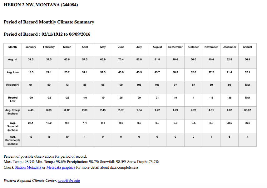
There are four definitive seasons in our part of the country and each has general characteristics of it’s own. In general the wettest times of the year are late fall/early winter (November and December) and late spring/early summer (May/June) with the driest times of the year in mid summer (July/August) with a notable exception across far northeastern Lincoln County up near Eureka and Rexford. This region has a more continental climate with wetter summers and drier winters. I will elaborate more on that a bit later. Temperatures also follow a similar trend with highly changeable readings in the spring and fall with more consistently cold readings in the winter and correspondingly warm to hot temperatures in the summer. Many people feel that our summers are rather short and our winters long and perhaps they are for those that are used to more southern and warmer climates. Here is a general breakdown of each season for our region with the exception of the Rexford and Eureka area in far northern Lincoln County which I will write about towards the end of this article. The seasons as I have listed them will be referenced by their meteorological seasons and not as you would find them on a calendar. In general the wettest locations across North Idaho and Northwest Montana are the Priest Lake area, Priest River area and Sandpoint area in North Idaho valleys. In Northwest Montana, Yaak, Bull Lake and Heron are the wettest locations in the valleys. The Selkirk Mountains in North Idaho and the Cabinet Mountains in Northwest Montana are the wettest locations overall in the region.
Winter Season: December 1 - February 28 or 29
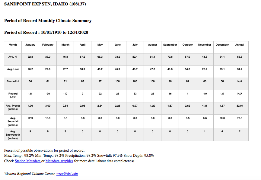
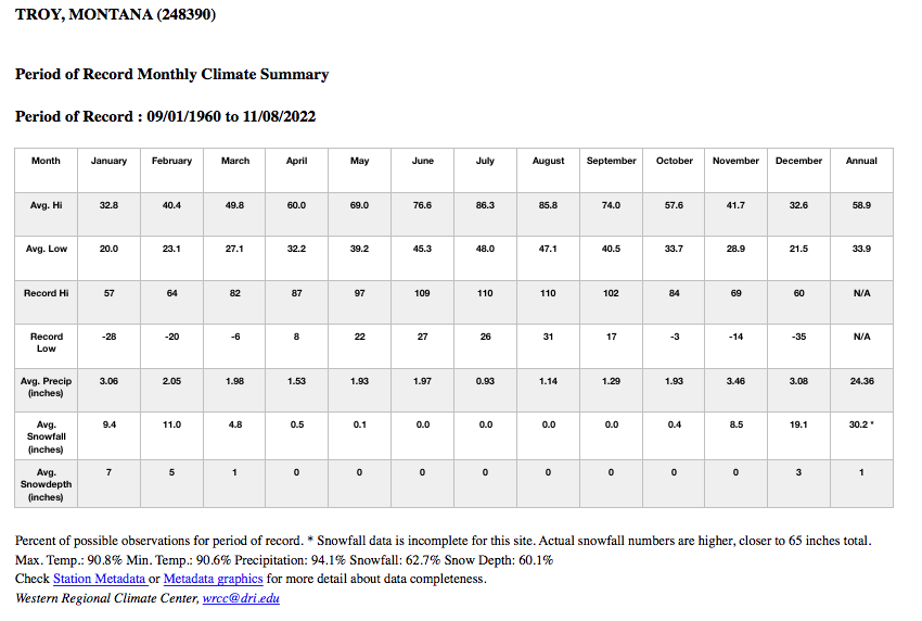
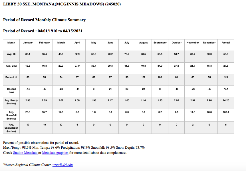
Winter in the Northern Rockies of North Idaho and Northwest Montana can in general be summed up as a cloudy, cold and damp period with frequent rounds of mostly light rain and snow as weather systems typically move easily off the North Pacific or out of Canada bringing much colder air, windy conditions and potentially snowy conditions. If surface and upper level high pressure both build across the region for extended periods of time following a healthy snowpack on the ground in the valleys then prolonged periods of low clouds and freezing fog often develop while mountains will see plenty of sunshine being above the low clouds in the valleys. Heavy, flooding rains or heavy snows are rare and infrequent in North Idaho and Northwest Montana but occasionally do happen. Average snowfall across valley locations ranges from a low amount of around 40 inches in the Hot Springs/Plains area due to the rain (snow) shadow effect of the Coeur d’Alene Mountains to the west to 103 inches at McGinnis Meadows south of Libby due to it’s higher elevation and proximity to the Cabinet Mountains. In addition freezing rain usually occurs at least once each winter across the valley locations as cold air becomes trapped in the valleys while mountains warm up creating the environment for freezing rain. Mountain precipitation is considerably higher than the surrounding valleys across much of the region with snowfalls above 4,000 feet averaging between 150 inches to almost 300 inches. Temperature extremes during the winter months can range from -50 recorded in Eureka during the month of December to 71 recorded in Thompson Falls during the month of February. Snow does not usually accumulate to great depths in the valleys where people reside with even the most extreme years seeing less than 5 feet of accumulated or settled snow on the ground at any one time, 55 inches being the most extreme snow depth on record in December of 1996 in Bonners Ferry and in January of 1954 in McGinnis Meadows. Mountain snow depth is often considerably higher with depths greater than 100 inches common above 6,000 feet in the mid to late winter months but again, no one lives at those elevations.
Spring Season: March 1 - May 31
Spring features highly changeable weather with all four seasons sometimes occurring in one day. Snow typically begins melting in the valleys around the beginning of March with mid slope mountain snowpack typically beginning to melt in mid April and high elevation snowpack beginning in early May. In most years valleys are typically snow free by mid to late March. Weather patterns become more variable with occasional bouts of low elevation snow and a mix of sunshine and showers as the atmosphere becomes more unstable. The seasons first thunderstorms usually occur in mid April and often are accompanied by brief heavy rains, gusty winds and sometimes what is known as graupel, which is “soft hail.” This is common in the early to mid Spring months as the atmosphere is often still cold enough to support snow but the lowest elevations are too warm so what locals call “pop-corn snow” often results which is what graupel is. Fog and low cloudiness in the valleys will break up during the late morning hours as the daylight grows increasingly longer and temperatures rise. Occasional extended periods of a day or more of widespread rains and higher elevation snows are also more common in the spring as the jet stream gradually becomes weaker. In addition gusty winds with weather systems become more common with afternoon hours typically becoming breezy regardless of any passing weather systems. Extremes can range from -28 in McGinnis Meadows recorded in March all the way up to 102 recorded in Libby in May. One other note that sometimes surprises new comers to the region is May frequently has much more precipitation than April and for most locations is the 2nd to 3rd wettest month of the year.
Summer Season: June 1 - August 31
The summer season often begins cool and wet in June. The old saying across the region is that “it can rain 7 days out of 6 in June.” June historically is a very wet month across the entire region and in the case of Eureka, it is the wettest month of the year. Precipitation in the summer ranges from periodic all day rain events which are not very common at all to convective showers and thunderstorms which typically occur in the evenings and overnight hours. Around the first to second week in July conditions typically change rather abruptly from cool and wet to hot and dry, often within a few days. There have been summers where it has been very cool and wet throughout the summer but this is very much the exception and not the rule. The region averages about 18 to 25 days a year with thunderstorms, most of these occur during the summer months with a couple occurring in the late spring and early fall. Lightning displays are often vivid and spectacular with frequent cloud to cloud and cloud to ground strikes lighting up the night skies. Fire season also reaches its peak during the summer, typically in late July through the first 2 weeks of August. Fire season in North Idaho and Northwest Montana is highly dependent on the May and June rains and the intensity and frequency of summer thunderstorms. Nights are often comfortably cool with temperatures typically in the 40s and 50s while afternoon temperatures are often warm to hot, especially in the valleys of Northwest Montana such as around Troy, Libby and Thompson Falls. These hotter valleys will typically see at least one day a year of 100 degrees or hotter while the rest of the region usually does not see 100 degree days as they are rather rare. During hot spells, night time temperatures often remain uncomfortably warm on the hillsides and mountainsides bordering the valleys as these areas are located in thermal belts that do not cool off very well. Afternoon and early evening breezes are common during the summer months.
Fall Season: September 1 - November 30
Fall begins in the Northern Rockies in most years in September with some years starting as early as mid to late August in the higher elevations. Typically trees begin to change colors in mid September and peaking in early October. The start of the fall season is typically rather dry and warm although frost becomes more likely and common by mid September especially in Northwest Montana valleys. Some years will even see frost occur as early as August but this is not common. By the middle of October the weather patterns typically begin to transition to more active with more frequent passing weather systems with valley rains and higher elevation snows. Low elevation snows have occurred as early as early September but this is extremely rare. Snow typically begins to fall in the valleys towards the end of October but usually does not begin accumulating until mid to late November in most years. Once the seasons first good wetting fall rains arrive and the ground is wet fog and low clouds in the valleys begin to develop earlier and last later each day until typically by the start of November the low clouds remain throughout the day with little in the way of sunshine. Temperatures usually see a steady decline, from warm to sometimes hot at the start of September to cool to cold by the start of November.
Northern Lincoln County Climate around Eureka and Rexford
I had stated earlier that the climate of northern Lincoln County around Eureka and Rexford was a bit different than the climate of the rest of the Northern Rockies. This region has a more continental climate which features more precipitation during the warmer months of the year and less precipitation during the colder months of the year. Precipitation here is more evenly distributed throughout the entire year but at the same time, is also one of the drier regions as well. Snowfalls are lighter in this area, summer thunderstorms more frequent and temperatures more extreme. Due to this areas proximity to the Continental Divide polar and arctic outbreaks from east of the Continental Divide affect this area more frequently than the rest of the region. Instability is also greater here in the summer months as weak weather systems pass along the Canadian border and trigger afternoon and evening thunderstorms that are more frequent than the rest of Northwest Montana. In this area, May, June and July are the wettest months while February is the driest month.
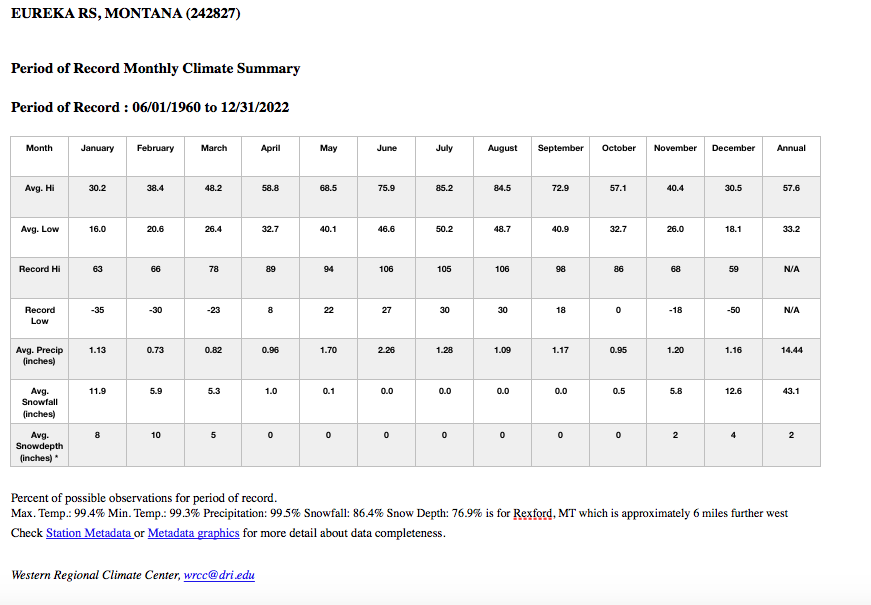
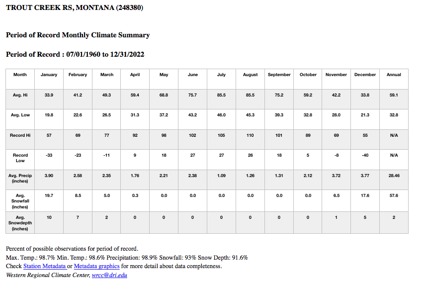
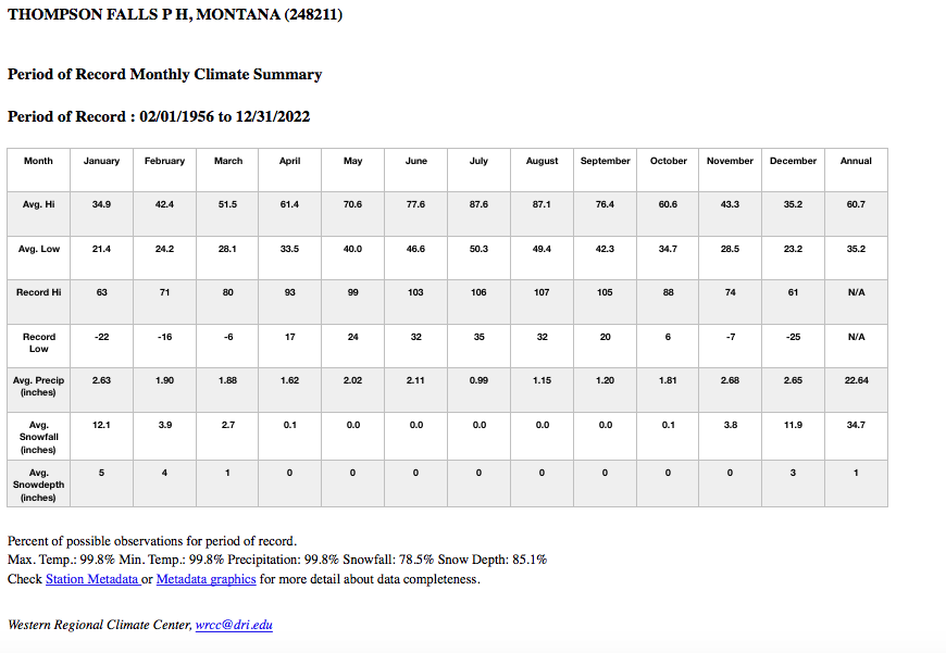
Hopefully this information helps clear up some of the myths regarding “so called snow over the roof” that I have heard many people claim this region sees. A snow depth of 55 inches would not qualify for snow above the roof of someone’s house. There are of course drifts of snow that can occur but settled snow depths in general are not that deep across our region where people live and many like it that way. For more details on climatic data please see the townsites listed below with their climate data or visit the Western Regional Climate Center’s website which is www.wrcc.dri.edu. I have included climatic data below for Bonners Ferry, ID, Priest River, ID, Sandpoint, ID, Troy, MT, Libby, MT, Heron, MT, McGinnis Meadows, MT, Eureka, MT, Trout Creek, MT, Thompson Falls, MT and Hot Springs/Plains, MT.